About 1.5 hours to Prabalmachi, then about 1 to 1.5 hours to the top
Starts at
Thakurwadi village, about 17 to 20 km from Panvel
Good for
Experienced trekkers with a head for heights
JFMAMJJASOND
Best: Oct to Feb
October to February is the safest time, with dry rock and clear views of Matheran and Prabalgad. In the monsoon the steps are wet and the summit gets crowded, which is when accidents happen.
कलावंतीण दुर्ग . Also called or spelled Kalavantin, Kalavantin Pinnacle, Kalavantinicha Sulka.
How I made this guide
I put this guide together from sources I trust: the ASI, Maharashtra Tourism, state gazetteers, historians and recent trekker reports. I haven't checked it on the ground for this page yet. When I go, I'll add what it's really like on the day, and my own photos.
Status,
Kalavantin Durg is open to trekkers all year. ST buses run from Panvel bus stand to Thakurwadi in the morning; check timings, which change by season.
Heads up before you go
The final rock-cut steps have no railings and drop into a deep valley; trekkers have died here, often while taking photos. Don't go if you're new to trekking or uneasy with heights, never stop on the steps for selfies, and avoid it in heavy rain. Go with someone who knows the route.
The quick version
Challenging difficulty
Time
About 1.5 hours to Prabalmachi, then about 1 to 1.5 hours to the top
Height
About 686 m (2,250 ft)
Starts at
Thakurwadi village, about 17 to 20 km from Panvel
Good for
Experienced trekkers with a head for heights
Straight from my guide, last updated 17 November 2026. Timings and fees do change, so check locally before you set off.
Kalavantin Durg is the pinnacle near Panvel with the zigzag steps cut into its face, and I’ll be straight with you: it’s one of the most exposed treks near Mumbai. The steps have no railings and drop into a deep valley, and people have died here. If you’re an experienced, careful trekker on a dry day, it’s an unforgettable climb with views to Matheran. If you’re new to trekking, start with something else and come back.
Why Kalavantin matters
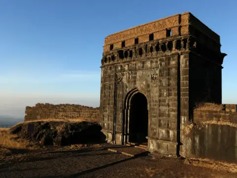
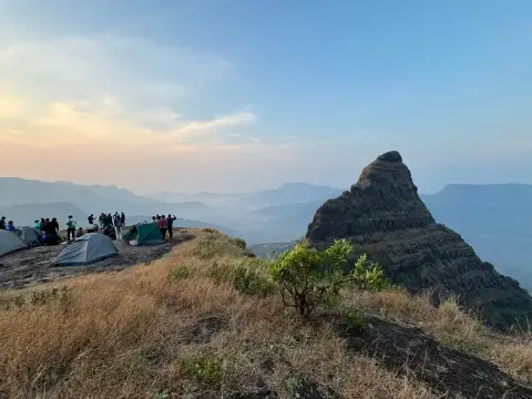
Despite the name, there’s no fort on top. Kalavantin is a rock pinnacle that served as a watch post over the old Mumbai–Pune route. Little is known for certain about it. Local tradition says it was cut for a queen named Kalavantin, around the same time as its neighbour, Prabalgad. Prabalgad, also called Muranjan, sits right beside it, separated by a col.
The route
Thakurwadi to Prabalmachi (about 1.5 hours). A marked trail climbs to Prabalmachi, the village on the plateau between Kalavantin and Prabalgad.
Prabalmachi to the foot of the pinnacle. A steep trail through the trees to the col.
The steps (about 1 to 1.5 hours). Rock-cut steps zigzag up the face of the pinnacle at about 60 degrees. Some are nearly two feet high, and the lower ones are worn. You’ll need your hands. There are no railings.
Allow about 2 hours from Prabalmachi to the summit and back.
How to do the steps safely
Use your hands and keep three points of contact.
Never stop on the steps for selfies. That’s how most accidents here have happened.
Don’t go when the rock is wet.
Avoid crowded weekends. Queues on narrow steps are risky.
Come down facing the rock if you feel unsure.
How to reach Thakurwadi
From Mumbai: about 60 km. Train to Panvel, then an ST bus from Panvel bus stand towards Thakurwadi (morning buses; check timings), or a shared auto or cab.
From Pune: about 120 km via the expressway and the Panvel exit.
Pair it with Prabalgad
Prabalgad stands right next to Kalavantin, also reached from Prabalmachi. Doing both makes a long day, about 2 to 2.5 hours more for the Prabalgad round trip. Many groups camp at Prabalmachi and do one each day.
My tips
Start early to beat the heat and the crowds.
Wear proper trek shoes with a good grip.
Carry 2 to 3 litres of water.
Be honest with yourself about heights. Turning back is always the right call if you’re unsure.
You asked, I answered
Is Kalavantin Durg dangerous?
It can be. The final rock-cut steps are steep, have no railings and drop into a deep valley, and trekkers have died here. It's safe enough for experienced, careful trekkers in dry weather. It's not a first trek.
How long is the Kalavantin Durg trek?
About 1.5 hours from Thakurwadi to Prabalmachi village, then about 1 to 1.5 hours up the pinnacle. Allow about 2 hours for the round trip from Prabalmachi to the top and back.
Is Kalavantin Durg a fort?
Not really. Despite the name, there's no fort on top: it's a pinnacle used as a watch post. Local tradition says it was named after a queen called Kalavantin.
Can I do Kalavantin and Prabalgad together?
Yes. They stand side by side above Prabalmachi, separated by a col. Doing both makes a long day; many groups camp at Prabalmachi.
How do I reach Thakurwadi?
By train to Panvel, then an ST bus from Panvel bus stand, or a shared auto or cab, about 17 to 20 km.
Written by Vinay Kadam for Trek Maharashtra. Published 17 November 2026, updated .