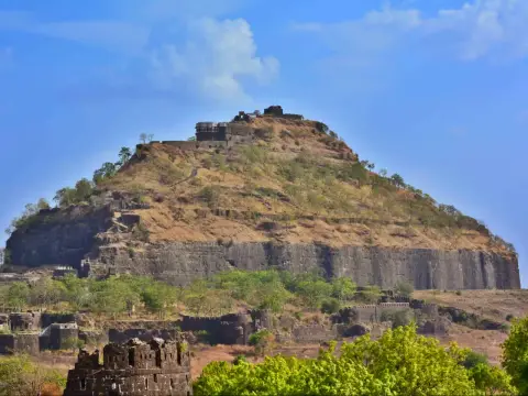
About 2 hours from Harshewadi; 2 to 2.5 hours from Nirgudpada
Starts at
Harshewadi, 13 km from Trimbakeshwar, or Nirgudpada
Good for
Fit trekkers with a head for heights
JFMAMJJASOND
Best: Sep to Feb
September to February is the safest time: the rock is dry and grippy and the views are clear. In the monsoon the hills are beautiful, but the steps are wet and crowded.
हरिहर . Also called or spelled Harshagad, Harihar Killa.
How I made this guide
I put this guide together from sources I trust: the ASI, Maharashtra Tourism, state gazetteers, historians and recent trekker reports. I haven't checked it on the ground for this page yet. When I go, I'll add what it's really like on the day, and my own photos.
Status,
Harihar is open to trekkers all year. Weekends, especially in the monsoon, are very crowded on the steps.
Heads up before you go
The final rock-cut steps are close to vertical, with no railing, only niches cut in the rock to hold. Don't go if heights make you anxious, never climb the steps in heavy rain, and keep three points of contact all the way. On busy weekends people get stuck in queues on the steps; go on a weekday.
The quick version
Challenging difficulty
Time
About 2 hours from Harshewadi; 2 to 2.5 hours from Nirgudpada
Height
About 1,120 m (3,676 ft)
Starts at
Harshewadi, 13 km from Trimbakeshwar, or Nirgudpada
Good for
Fit trekkers with a head for heights
Straight from my guide, last updated 14 November 2026. Timings and fees do change, so check locally before you set off.
Harihar is the fort you’ve seen in photos: a staircase cut into a cliff at about 80 degrees, climbing straight up the rock like a stone ladder. It’s short and it’s thrilling. It’s also not for everyone. If you’re fit and calm on heights, it’s one of the great climbs of Maharashtra. If heights make your legs shake, pick another fort and save this one for later.
Why Harihar matters
Harihar sits in the Trimbak range near Nashik, above the old trade route through Gonda Ghat between Maharashtra and Gujarat. With its near-vertical steps cut into the rock, the fort was close to impossible to attack. The British took it in the 19th century. Today it’s purely a trekking fort.
The two routes
Route
Start
One way
Time
What it’s like
Harshewadi
Harshewadi, 13 km from Trimbakeshwar
About 2.5 km
About 2 hours
Shorter and gentler; most people use it
Nirgudpada (Kotamwadi)
Nirgudpada, about 20 km from Trimbakeshwar
About 3.4 km
2 to 2.5 hours
Longer; quieter
Both trails meet on the plateau below the fort, before the steps.
The steps
From the plateau, the famous staircase climbs the face of the hill at about 80 degrees. The steps are narrow and worn in places, with niches cut on both sides for your hands. Near the top they turn into a short, curving passage through the rock and end at the gate.
How to do them:
Face the rock and use your hands. Three points of contact, all the way.
Go up and come down slowly. Coming down is harder; face the rock again if you need to.
Leave your bag light. Both hands should be free.
Don’t stop on the steps for photos when others are queued behind you.
What to see on top
The view across the Trimbak range of the Sahyadri.
Small temples to Hanuman and Shiva, with a Nandi.
A pond and rock-cut cisterns, and an old storage building that once held grain.
How to reach the start
From Nashik: to Trimbakeshwar by bus or taxi, then a taxi or auto to Harshewadi or Nirgudpada.
Go on a weekday. Weekend queues on the steps are the biggest risk here.
Start early, so you’re on the steps before the afternoon heat.
Wear proper trek shoes with good grip. No sandals, no new shoes.
Watch for monkeys on the steps; keep food packed away.
Turn back if it’s raining hard. The fort will still be there.
You asked, I answered
How steep are the Harihar Fort steps?
The final rock-cut staircase climbs the face of the hill at about 80 degrees, almost like a stone ladder, with niches cut on either side to hold on to. Counts of the steps vary from about 90 to 200, depending on which section is counted.
How long is the Harihar Fort trek?
About 2 hours one way from Harshewadi, the easier base village, or 2 to 2.5 hours from Nirgudpada (Kotamwadi). Both trails meet on the plateau before the steps.
Is Harihar Fort safe for beginners?
It's not a first trek. The walk to the steps is easy, but the steps themselves need fitness, a steady nerve and good grip. If heights make you anxious, choose another fort.
How do I reach Harihar Fort?
From Trimbakeshwar, take a taxi or auto to Harshewadi, about 13 km, or to Nirgudpada, about 20 km. Trimbakeshwar is reached from Nashik.
Can I do Harihar in the monsoon?
Many people do, but it's the riskiest time: the steps are wet and weekend crowds back up on them. If you go, go on a weekday, and turn back if it's raining hard.
Written by Vinay Kadam for Trek Maharashtra. Published 14 November 2026, updated .