Trek Maharashtra

Prabalgad Fort

Time
About 1 hour to Prabalmachi, then about 1 to 1.5 hours to the top
Starts at
Thakurwadi village, about 5 km from Shedung on the old Mumbai-Pune highway
Good for
A full day; pairs with Kalavantin
Ask
Map of Maharashtra with Prabalgad Fort marked in Raigad district, Konkan division Mumbai Pune Chh. Sambhajinagar Nagpur
Where it is Raigad district, Konkan division The pin marks the district, not the exact spot. Map outline: DataMeet India community, CC BY 4.0
Local name

प्रबळगड . Also called or spelled Prabalgad, Muranjan, Prabalgad Killa.

How I made this guide

I put this guide together from sources I trust: the ASI, Maharashtra Tourism, state gazetteers, historians and recent trekker reports. I haven't checked it on the ground for this page yet. When I go, I'll add what it's really like on the day, and my own photos.

Status,

Prabalgad is open to trekkers all year. ST buses run from Panvel bus stand to Thakurwadi; check timings, which change by season.

Heads up before you go

The summit is a large plateau covered in dense forest, and it's easy to lose the path up there. Take a local guide from Prabalmachi to find the temple and water tanks, start early so you're down before dark, and don't wander off the trail near the cliff edges.

The quick version

Moderate difficulty
Time
About 1 hour to Prabalmachi, then about 1 to 1.5 hours to the top
Height
About 700 m (2,300 ft)
Starts at
Thakurwadi village, about 5 km from Shedung on the old Mumbai-Pune highway
Good for
A full day; pairs with Kalavantin

Straight from my guide, last updated 18 November 2026. Timings and fees do change, so check locally before you set off.

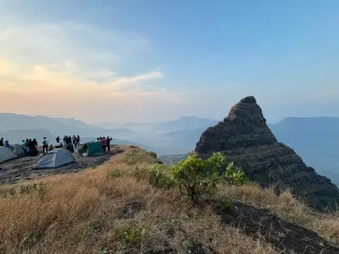
Prabalgad is the fort I’d send a friend to when they want a proper day out near Mumbai without the exposed steps of its neighbour, Kalavantin. It’s a long, steady climb to a huge forested plateau with views over Matheran. The walking isn’t hard. Finding your way on top is, so go with a local guide.

Why Prabalgad matters

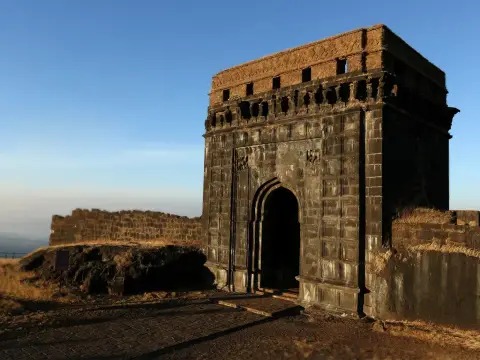
You’ve probably seen it already: the big flat-topped hill beside the Mumbai-Pune Expressway, with the sharp pinnacle of Kalavantin next to it. The fort was once called Muranjan and may have been built to watch over the old ports of Panvel and Kalyan. In the mid-1650s it was taken for Chhatrapati Shivaji Maharaj, by most accounts by Abaji Mahadeo, and renamed Prabalgad. Under the Treaty of Purandar in 1665 it went to the Mughals, and the Marathas took it back after the treaty broke down.

The route from Thakurwadi

Stage From Time What it’s like
To Prabalmachi Thakurwadi About 1 hour A wide, unpaved track up to the village on the plateau below both forts
To the cleft Prabalmachi About 30 minutes Keep the fort on your left; the path climbs to a cleft in the rock
To the top The cleft About 1 hour Steeper, through forest, up to the summit plateau

Two other routes exist: a ridge from Poinj village, about 1.5 to 2 hours, and a longer way down from Matheran through Aaksarwadi. For a first visit, use Thakurwadi.

Prabalmachi village

Prabalmachi sits on a shelf of flat ground between Prabalgad and Kalavantin. A machi is a terrace below a fort, and this one is a working village. Groups camp here, and it’s where you’ll find a local guide for the fort.

What to see on top

  • The plateau itself: wide, flat and wooded, much bigger than it looks from below.
  • A Ganesh temple and two or three water tanks.
  • Ruins of old structures scattered through the forest.
  • The views: Matheran, Kalavantin, and on a clear day Irshalgad and Karnala.

How to reach Thakurwadi

  • From Mumbai: train to Panvel, then an ST bus from Panvel bus stand to Thakurwadi. By car, take the old Mumbai-Pune highway to Shedung; Thakurwadi is about 5 km on.
  • From Pune: via Lonavala, Khopoli and Chowk to Shedung, then Thakurwadi.

My tips

  • Take a local guide on top. The forest is dense and the paths split; people do get lost.
  • Start by 7 am so you have time to explore the plateau and still get down in daylight.
  • Carry water and food. There’s water on the fort, but don’t count on buying food on the trail.
  • Don’t add Kalavantin on a whim. Its rock-cut steps are a separate, harder climb. Plan it, or save it for another day.
  • Leave no trace. Prabalmachi is someone’s home.

Places near Prabalgad

  • Kalavantin Durg, the pinnacle next door, reached from the same village.
  • Matheran, across the valley to the east.
You asked, I answered

How long is the Prabalgad trek?

About 1 hour from Thakurwadi to Prabalmachi village, then about 1 to 1.5 hours to the top. Allow 3 to 4 hours up from the base, and a full day overall.

Is Prabalgad difficult?

It's a moderate trek. The path is not technical, but it's long, and the forested summit is easy to get lost on. Take a local guide from Prabalmachi.

What was Prabalgad called before?

Muranjan. It was taken for Chhatrapati Shivaji Maharaj in the mid-1650s and renamed Prabalgad.

Can I do Prabalgad and Kalavantin on the same day?

Yes, they stand side by side above Prabalmachi. It makes a long day, so many groups camp at Prabalmachi and do one fort each morning.

How do I reach Thakurwadi?

Train to Panvel, then an ST bus from Panvel bus stand to Thakurwadi, or a cab via Shedung on the old Mumbai-Pune highway.

Written by Vinay Kadam for Trek Maharashtra. Published 18 November 2026, updated .

Keep exploring Konkan division

See all
UNESCO Moderate difficulty

Raigad, Konkan division

Raigad Fort

Hill fort
Technical difficulty

Raigad, Konkan division

Lingana Fort

Hill fort

Where are you coming from?

I will show road distances from this city wherever my guides have them. I only remember it on this phone.